PREVIEW!

Copy link

Developer Settings

Home / Weather News /

Breakfast Brief - Busy day for East, Four Corners & Cali

09:00 AM
April 15, 2025

Breakfast Brief
Busy day for East, Four Corners & Cali

A large storm system will be impacting the Great Lakes and Northeast down to the Southeast. To the West, a weak low-pressure system brings scattered rain and mountain snow to the Four Corners and northern California. The Breakfast Brief is published Monday through Friday at 5:00 a.m. Eastern Time.

A spring clipper continues slowly east today after bringing rain, severe thunderstorms and snow on Monday. More of the same is expected today, and it's already making for a soggy morning along the cold front in the Appalachians and into the Northeast, with snow falling in the Upper Great Lakes. See the WeatherRadar?

The good news is that the front will clear the Southeast just after lunch, but the busy skies will remain to the north in the Mid-Atlantic, Northeast, Ohio Valley and the Great Lakes. Early mild temperatures in the Northeast will bring the chance for thunderstorms as far north as Maine and stretching down to central Pennsylvania, as seen on the WeatherRadar. Colder temperatures and snow will replace the wet and stormy weather by the evening as the front shifts east.

Not to be outdone, gusty winds accompany this storm. The WindRadar shows gusts in the 30 to 50 mph range, with higher gusts likely in the mountains for the entirety of the eastern third and up into the Upper Great Lakes.

Tuesday afternoon temperatures at 4 p.m. Eastern Time.

Wondering why the morning may be warmer than the afternoon in your area? With the timing of this cold front, many may reach their high temperature early in the day. Pittsburgh, Pa., and Morgantown, W. Va., will reach their highs around lunchtime before the front brings in the colder air for the afternoon and evening. Watch the TemperatureRadar to see this in action.

To the West, a weak low pressure will produce showers, mountain snow and even a few thunderstorms for the Four Corners and into northern California. These will start early and move north and northwest throughout the day, as seen on the WeatherRadar. Have an umbrella and your app alerts switched on in case of heavy downpours or thunderstorms.

News we're covering today

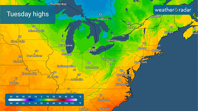
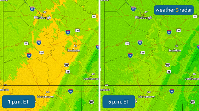
  • Spring clipper impacts Northeast corridor
  • Start planning your Easter weekend activities

Things you may have missed

More spring snowread more
International spring photo collectionread more

App news

The WeatherRadar shows forecasts up to four days out! It's a great tool for predicting what's ahead for your spring break holidays.

Becca Parker
More on the topic
rjukan-mirrors
Sunday, December 7, 2025

In the base of a valley

A town that uses mirrors for sunlight
Algunos modelos meteorológicos estacionales nos permiten conocer cómo podría comportarse la estación.
Tuesday, December 2, 2025

What to expect

Meteorological Winter is here
Thursday, November 27, 2025

An American tradition

History of Thanksgiving
All weather news
This might also interest you
estrellas fugaces
Saturday, December 13, 2025

When and where

The Geminid meteor shower peaks
Wednesday, December 10, 2025

Atmospheric River

Flood threat grows in Pacific Northwest
Tuesday, December 9, 2025

Daily briefing

A few wintry headaches
All articles
Weather & Radar

Weather & Radar is also available on

Google Play StoreApp Store

Company

Contact us Privacy policy Legal info Accessibility statement

Services

Uploader

Socials

instagramfacebookthreadslinkList